RANGE
Jump to: Mission Objectives, Mission Instrumentation, Mission Parameters, Additional Information
Mission Photos:
Courtesy of Georgia Institute of Technology
Mission Objectives:
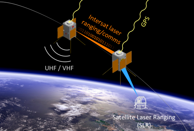
RANGE (The Ranging And Nanosatellite Guidance Experiment) is a cubesat mission consisting of two satellites in a leader-follower formation. The primary objective of the mission is to improve the relative and absolute positioning capabilities of small satellites. This will be done through ground-based laser ranging, a dual-frequency GPS receiver, and an intersatellite laser ranging system (operating at 1550 nm). The goal is to achieve cm-level absolute positioning and mm-level relative positioning knowledge.
SLR will be used together with the positioning information gathered from the on-board GPS receivers and intersatellite ranging system for precise orbit determination. The nadir-pointing side of each RANGE spacecraft has four retroreflectors for increased field-of-view, in addition to a fifth pop-out retroreflector on one side for attitude determination experiments.
RANGE Mission Parameters:
| Satellite | RANGE (satellite A) | RANGE (satellite B) |
| Sponsor: | Georgia Institute of Technology | Georgia Institute of Technology |
| Expected Life: | 1 year | 1 year |
| Primary Applications: | Improve the relative and absolute positioning capabilities of small satellites | Improve the relative and absolute positioning capabilities of small satellites |
| Primary SLR Application: | Precision orbit determination | Precision orbit determination |
| Launch Date: | July/Aug 2018 | July/Aug 2018 |
| COSPAR ID: | ||
| SIC: | 1077 | 1078 |
| Satellite Catalog (NORAD) Number: |
||
| NP Bin Size: | 15 seconds | 15 seconds |
| RRA Diameter: | ||
| RRA Shape: | 4 Nadir Canted Pyramid and 1 Nadir Canted on Flip-Out Mount | 4 Nadir Canted Pyramid and 1 Nadir Canted on Flip-Out Mount |
| Reflectors: | 5 | 5 |
| Orbit: | ||
| Inclination: | 97.7 degrees | 97.7 degrees |
| Eccentricity: | 0 degrees | 0 degrees |
| Altitude: | 575 km | 575 km |
| Period: | 5770 sec (96.2 min) | 5770 sec (96.2 min) |
Additional Information:
Web sites:
- Georgia Tech's School of Aerospace Engineering website