Scientific Research Through Laser Ranging
The ILRS supports scientific research and data analysis using Satellite and Lunar Laser Ranging data and their products. The aim of these activities is primarily focused on geodetic and geophysical parameter estimation and geophysical model development. Furthermore, the main thrust of these activities addresses the needs of IERS with products that contribute to the development of an ever more accurate International Terrestrial Reference Frame (ITRF). The unique ability of ILRS to sense the Earth System center of mass with high accuracy, makes these products invaluable in the development of the ITRF, the prime product is the Global Geodetic Observing System (GGOS). The ILRS data and products are collected and generated under strict standards and they contribute to a wide range of scientific, engineering, and operational applications and experimentation.
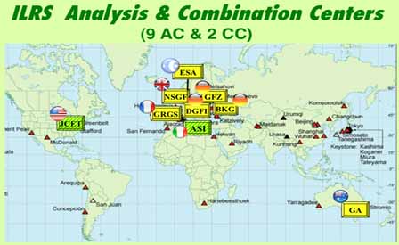
In addition to collecting, merging, archiving and distributing Satellite Laser Ranging (SLR) and Lunar Laser Ranging (LLR) the ILRS interacts with the other IAG (Int. Assoc. of Geodesy) services under the GGOS umbrella, to harmonize the standards and conventions used for its operations and its data analysis and product generation activities. These activities are coordinated, supervised and validated by the Analysis Working Group, with the support of all Analysis Centers and Associate Analysis Centers. The official products of the ILRS are produced by the Combination Centers (primary and back-up) to ensure a unique product for the users with the highest accuracy and fully validated prior to its release. The service encourages international collaboration and strives to include as many different groups from various countries as possible, with a similar variety in the utilized software.
Recent News
Read more...
Tom received his B.S. in Engineering Physics and his Ph.D. in Astro-Geophysics from the University of Colorado in 1961 and 1967 respectively. From 1966 to 1968, he served as Chief of the Astronomy Branch at NASA Marshall Space Flight Center and as Project Scientist on the Spacelab Coronagraph. At GSFC, where he moved in 1968, Tom received numerous NASA awards for his pioneering work on Radio Astronomy Explorer 1 and 2 and several generations of Very Long Baseline Interferometry systems. Tom developed the Totally Accurate Clock (TAC), an inexpensive GPS timing receiver that found widespread use in a number of global networks. Tom was named a Fellow of the American Geophysical Union (AGU) in 1991 and a Fellow of the International Association of Geodesy (IAG) in 1999. Tom was also a pioneer in amateur and digital radio; he designed and flew several low cost satellites for relaying amateur radio messages around the globe and is a past president of AMSAT. He was one of only 50 initial inductees into the CQ Amateur Radio Hall of Fame, a list which included such engineering luminaries and inventors as Guglielmo Marconi (radio), Samuel Morse (telegraph), Nikola Tesla (HF generators and radio), and John Bardeen and William Schockley (transistor). Tom retired from GSFC in 2001 but remained active in Amateur Radio activities.
Those of us who worked with Tom during the Crustal Dynamics period remember him as a brilliant mind, a very interesting and sometimes caustic character, but someone who was kind, supportive, and very helpful to those of us around him. We will miss him.
Meetings
Many meetings have been canceled or postponed due to COVID-19. Please see the Meetings page for futher information.


