RANGE
Jump to: Mission Objectives, Mission Instrumentation, Mission Parameters, Additional Information
Mission Photos:

Courtesy of Georgia Institute of Technology
Mission Objectives:
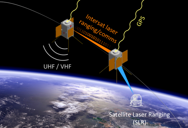
RANGE (The Ranging And Nanosatellite Guidance Experiment) is a cubesat mission consisting of two satellites in a leader-follower formation. The primary objective of the mission is to improve the relative and absolute positioning capabilities of small satellites. This will be done through ground-based laser ranging, a dual-frequency GPS receiver, and an intersatellite laser ranging system (operating at 1550 nm). The goal is to achieve cm-level absolute positioning and mm-level relative positioning knowledge.
SLR will be used together with the positioning information gathered from the on-board GPS receivers and intersatellite ranging system for precise orbit determination. The nadir-pointing side of each RANGE spacecraft has four retroreflectors for increased field-of-view, in addition to a fifth pop-out retroreflector on one side for attitude determination experiments.
RANGE Mission Parameters:
| Satellite | RANGE (satellite A) | RANGE (satellite B) |
| Sponsor: | Georgia Institute of Technology | Georgia Institute of Technology |
| Expected Life: | 1 year | 1 year |
| Primary Applications: | Improve the relative and absolute positioning capabilities of small satellites | Improve the relative and absolute positioning capabilities of small satellites |
| Primary SLR Application: | Precision orbit determination | Precision orbit determination |
| Launch Date: | July/Aug 2018 | July/Aug 2018 |
| COSPAR ID: | ||
| SIC: | 1077 | 1078 |
| Satellite Catalog (NORAD) Number: |
||
| NP Bin Size: | 15 seconds | 15 seconds |
| RRA Diameter: | ||
| RRA Shape: | 4 Nadir Canted Pyramid and 1 Nadir Canted on Flip-Out Mount | 4 Nadir Canted Pyramid and 1 Nadir Canted on Flip-Out Mount |
| Reflectors: | 5 | 5 |
| Orbit: | ||
| Inclination: | 97.7 degrees | 97.7 degrees |
| Eccentricity: | 0 degrees | 0 degrees |
| Altitude: | 575 km | 575 km |
| Period: | 5770 sec (96.2 min) | 5770 sec (96.2 min) |
Additional Information:
"Georgia Tech's R.A.N.G.E Cubesat Launched on December 3", (Press Release Georgia Institute of Technology, Dec.3, 2018).
Mission Page, Georgia Institute of Technology:
https://ae.gatech.edu/news/2018/12/its-space-georgia-techs-range-cubesat-launched-december-3"
The mission engaged with some ILRS stations, however the orbital ephemerides never converged. Communications with the satellites was lost and therefore no ILRS mission support ended up being provided.
Web sites:
- Georgia Tech's School of Aerospace Engineering website


