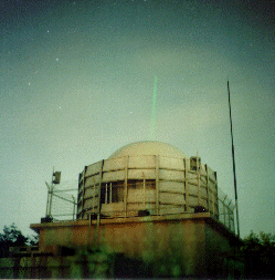
Tateyama
Jump to: Photo, Contact, Coordinates, News, Links

Back to Top
Tateyama Contact:
| Agency |
Communications Research Lab. |
| Mailing Address |
4-2-1, Nukui-kita, Koganei,
184-8795 Japan |
| Primary Contact |
| Contact Name |
Hiroo Kunimori |
| Telephone (primary) |
+81 423-27-7559 |
| Telephone (secondary) |
|
| Fax |
+81 423-27-6077 |
| E-Mail |
kuni@crl.go.jp |
| Secondary Contact |
| Contact Name |
|
| Telephone (primary) |
|
| Telephone (secondary) |
|
| Fax |
|
| E-Mail |
|
Tateyama Coordinates:
Approximate Position:
| X coordinate |
[m] |
-4000964.777 |
| Y coordinate |
[m] |
3375308.947 |
| Z coordinate |
[m] |
3632199.533 |
| Latitude |
[deg] |
35.9369 N |
| Longitude |
[deg] |
139.8481 E |
| Elevation |
[m] |
120.4 |
| Survey Method |
|
|
| Date Measured |
|
|
| Additional Information |
|
Tateyama News:
Local Events:
| Date |
2000-09-01 00 |
| Event |
See below |
| Additional Information |
The baseline length between Kashima
and Tateyama was shortened by about
5 cm. The crustal deformation at
Tateyama, located about100 km north-
east of the Izu islands, is caused
by a dike intrusion at about 3 km
depth and co-seismic offsets between
the islands. As of mid-September
2000, the crustal deformation around
Izu islands and the baseline
shortening had almost decayed. |
| Date |
Date |
| Event |
Event
co-seismic offsets between the Izu islands |
| Additional Information |
|
SLRMail Messages:
No SLRMail mesages found.
Tateyama Link:
http://ksp.crl.go.jp/


